II. The evolution of Taiwan's irrigation work
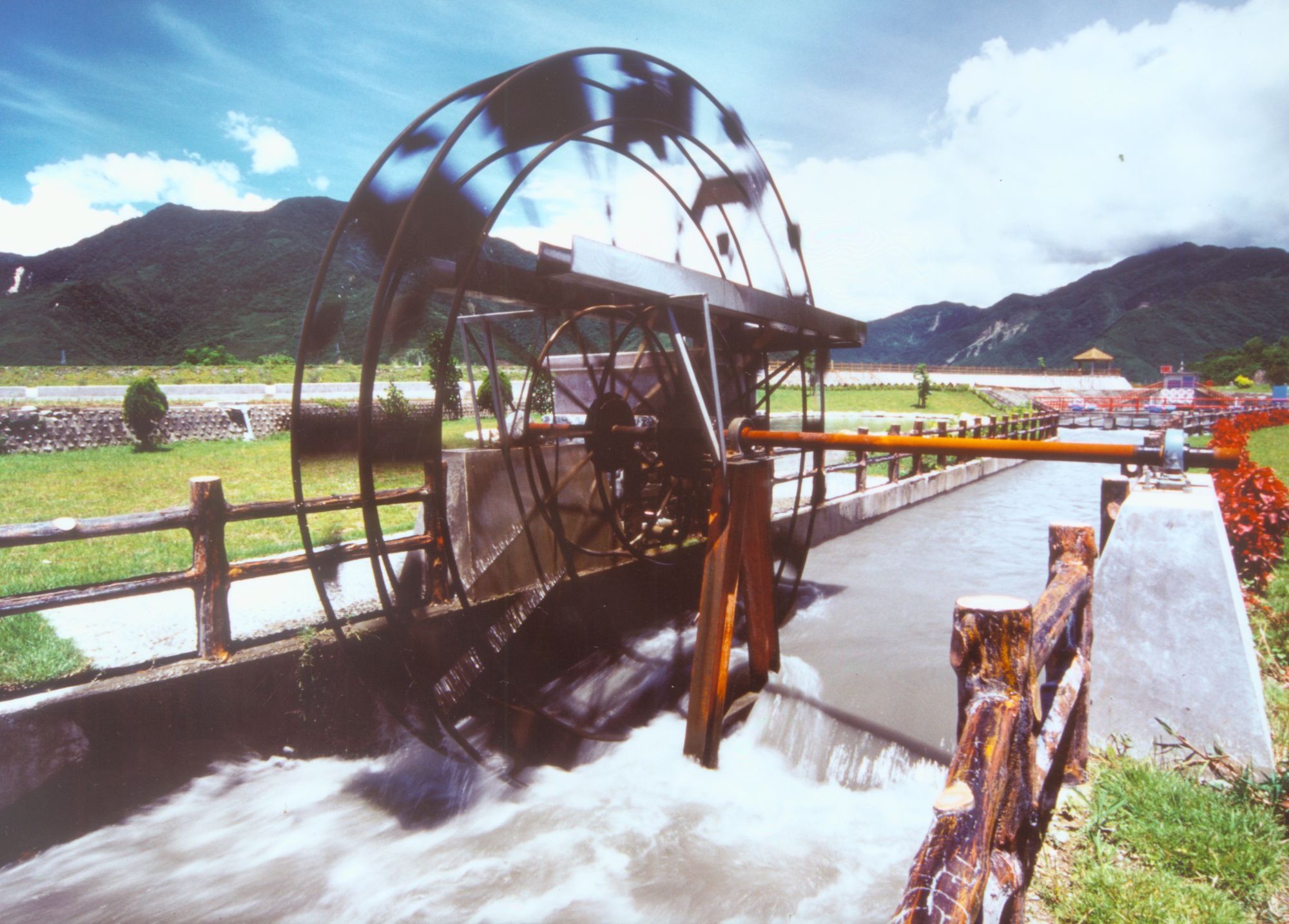
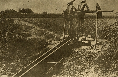
In the early years, farmers used simple methods to guide river water and adopted extensive farming modes such as "shift cultivation" and "abandoning cultivation." After the development of farmland irrigation, abundant streams and rivers were used as sources of water to expand irrigation areas. Therefore, building "canals" or irrigation channels gradually become a trend, and farming switched to "sedentary cultivation", with extensive approaches becoming intensive, and rice harvesting increasing from once to twice a year. The development of irrigation in Taiwan has a history of more than 300 years and can be divided into three stages: the Yuan, Ming and Qing Dynasties, the period under Japanese rule, and the post–Retrocession period:
(I) Yuan, Ming and Qing Dynasties
(1) Early Han Chinese Settlers Period (before 1622 AD)
Taiwan's earliest farmland irrigation can be traced back to the Yuan Dynasty. At that time, the first Han Chinese settlers arrived and scattered in various places that used simple methods to guide shallow water in wide rivers to irrigate farmland and cultivate rice. This represents the first tentative steps in irrigation development, though no irrigation facilities were built.
(2) Dutch rule in Taiwan (1623-1661)
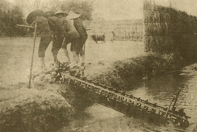
Irrigation facilities first appeared in Taiwan during the period of Dutch rule. At that time, the Dutch began to reward rice cultivation and set up grain warehouses in order to be self-sufficient in food. Agricultural irrigation became more and more important, so people started to build water storage facilities such as "wells" and "ponds" which marked the beginning of agricultural farmland irrigation development. The "Dutch-style weir” (grass pond) appeared in this period, a weir constructed from grass, wood, soil, stone and other materials, seen in areas of Lukang in Taichung and Tainan. Later, these structures were gradually constructed from soil and rocks.
Another common irrigation feature was water diversion structures made of wood or bamboo and called "water bridges." However, the relative lack of sophisticated engineering technology at the time, meant these structures were often destroyed when it flooded, so they were mainly used in more gently flowing rivers. The irrigation constructions introduced by the Dutch were recorded in various local chronicles, according to the irrigation entries in "Taiwan Prefecture Chronicles" volume 2 Regulation Chronicle by Gao Gong Gan. "Canre pond, in Wenxian village. Since the time of the Dutch, there was a person named Wang Canre who built a structure to store water and irrigate the fields, so it was called Canre pond." Wenxian village is now Rende Township, Tainan County. Chen Wenda wrote in volume 2 of "Taiwan County Chronicles," in entries on irrigation and Canre pond it says: "In the two pictures about Wenxian village, Wang Canre built it to irrigate fields during the Dutch era, hence the name." Fan Xian revised "Taiwan Prefecture Chronicles" volume 2, where in the irrigation entry of the Regulation Chronicle, it mistakenly referred the pond as "Cancha Pond." The above mentioned "Taiwan County Chronicles," also recorded: "There was a Dutch pond in Xinfeng village, the villagers built embankments to store the rainwater to irrigate the fields." Although it said the pond was built by the villagers but named by the Dutch, it is highly possible the pond was built on the orders of the Dutch. The pond was also known as the Dutch pond. Xinfeng village is now Guanmiao Township, Tainan County.
(3) Kingdom of Tungning in Taiwan (1662-1683 AD)
During the Kingdom of Tungning, the "King Farm" built by the Dutch was renamed "Government Farm" and became a source of food for the military and the public. In addition, military-agriculture land was cultivated by soldiers and Tainan was the center of cultivation. The cultivated farm was named "Yingpan Farm," mainly growing rice and actively promoting the production of sugarcane.
In southern Taiwan, the winter is dry and there is a lack of rainwater. In addition to adaptation farming to these conditions, special attention was paid to irrigation. As a result of promoting military-agriculture land, many ponds were built. In the Anping area: "Chengtian Spring," "Gongye Pond" (in Xinfeng village, today's Pizitou, Guanmiao, Tainan County), "Biyi Spring" (also known as "Baiyi Spring" in Xiangyangzai, XinfengVillage, Today’s Xiangyangzai, Xinhua Town, Tainan County), “Cao Spring” (in Xinfeng village, today’s Dataan, Guiren Township, Tainan County), “Pizaitou Pond” (in Wenxian Village, today’s Pizaitou, Rende Township, Tainan County), "San Laoye Pond" (in Yiren Village, today's Taiye, Guiren Township, Tainan County), "Xiangguan Pond" (in Yiren Village, today's Pizaitou, Guiren Township, Tainan County). Most of these ponds were built by Zheng family clans, civil and military officials, scholars and civilians. In addition, ponds named after military camps were built for soldiers and the remainder built and invested in by villagers. The irrigation facilities had different names depending on their geographic features:
Those on lower terrain, with embankments built to hold water, or intercept streams, were called "ponds" such as Hutou Pond and Jianshan Pond. Those at the bottom of the terrain with inexhaustible but not very wide springs were called "springs" and "lakes" such as Lotus Spring, Cao Spring and Bamboo Lake. Those with a source and regular flow were called "basins" and "pits," such as Jingshui Basin and Hongmaoliao Pit.
During the Kingdom of Tungning, due to uneven rainfall throughout the year and lack of water in winter and spring, only simple embankments could be built to store water on the Chianan Plain. This lack of irrigation facilities, as well as funds and labor, together with extensive agricultural management and the occasional change in cultivated land meant it was impossible to carry out large-scale fixed irrigation constructions. However, in terms of quantity, it increased considerably from the Dutch era with 70 ponds, 2 springs, 1 pool, 5 canals, and 25 water sources, though the irrigation area was still restricted and only the official rental fields were paddy fields; fields belong to civil and military officials were dry and wild land or "rain-fed paddy fields."
(4) Qing Dynasty rule in Taiwan (1684-1895)
Taiwan came under the rule of the Qing Dynasty in 1683 (The 22nd year of the reign of Emperor Kangxi). The increasing number of people moving to Taiwan led to growing demand for agricultural-use water. In order to obtain sufficient irrigation water, more irrigation facilities were built independently or jointly invested in by the private sector. Indeed, the irrigation works at this time could be described as being "privately built under government supervision." However, the focus of reclamation and administration was still around Tainan, and due to the high demand for sugarcane, farmers competed to plant sugarcane rather than rice. Later, due to the overproduction of sucrose, the increasing population of the island, the commodity value of rice increased which triggered large-scale "Paddy field conversion." During that period, irrigation development spread across the Chianan Plain, and even reached the Taichung Basin through the Changhua Plain. Total paddy field area increased to more than 200,000 hectares, with about 110,000 hectares irrigated by ponds and canals. The irrigation methods included diverting water from streams and storing rainwater in ponds and the use of groundwater.
At the time, due to the simplicity of irrigation channels and unsatisfactory water distribution, "fixed channels" were used to distribute water. Irrigation facilities were mostly canals in the north and ponds in the south. During this period, important facilities were built including the "Liugong Canal," "Da'an Canal" and "Houcun Canal" in Taipei; "Wanchangchun Canal" in Luodong, Yilan; "Babao Canal" in Changhua; "Huludun Canal" in Fengyuan, "Daojiang Canal" in Chiayi and “Caogong Canal" in Kaohsiung. Other than "Caogong Canal" which was built using official incentives, the other canals were built by locals or jointly with funds raised and operated by private individuals.
At the time, due to the simplicity of irrigation channels and unsatisfactory water distribution, "fixed channels" were used to distribute water. Irrigation facilities were mostly canals in the north and ponds in the south. During this period, important facilities were built including the "Liugong Canal," "Da'an Canal" and "Houcun Canal" in Taipei; "Wanchangchun Canal" in Luodong, Yilan; "Babao Canal" in Changhua; "Huludun Canal" in Fengyuan, "Daojiang Canal" in Chiayi and “Caogong Canal" in Kaohsiung. Other than "Caogong Canal" which was built using official incentives, the other canals were built by locals or jointly with funds raised and operated by private individuals.
The following is a brief introduction to several important ponds and canals:
1. Liugong Canal:
In 1736 (The 1st year of the reign of Emperor Qianlong), the family of Guo Xilu moved from the Changhua area to Zhonglun, Taipei City, and reclaimed Xingya Village (now Wufenpu, Songshan and Keelung Road). They independently raised funds to build a 20-kilometer-long canal to provide sufficient irrigation water. The engineering technology was not developed at the time, and the indigenous peoples also fought Han Chinese encroachment into their territory, making completion of the construction a daunting task.
The construction of Liugong Canal started in 1740 and made a significant contribution to farmland irrigation in the Taipei area, not only promoting the development of agriculture but also driving business prosperity in the region. However, with the rapid development of urban construction and industry and commerce, the vast farmlands of the past have gradually diminished. The canals, which were once the backbone of agricultural development, have faded away in the face of social change. In 1976, in concert with the implementation of urban construction plans and efforts to improve irrigation canals, drainage facilities were enhanced and canal pipelines introduced. However, changes in the environment saw the Liugong Canal stop water supply and irrigation operations in January 1984, and it was transformed from an agricultural irrigation channel into an urban drainage waterway. More recently, a "Restoration Plan for the Hydrophilic Space of the Liugong Canal-Taiwan University Section" has been rolled out in the Roosevelt Road Campus of National Taiwan University, breathing new life into the old canal.
2.Babao Canal:
Babao Canal is divided into two irrigation systems, the first and second canal, which originally introduced water from Zhuoshui River and then merged into the same system. The first canal is located near Bizitou, which is now Ershui Township, Changhua County. The first canal diverted water from Zhuoshui River to irrigate farmland including Dongluodong fort, Dongluoxi fort, Wudong fort, Wuxi fort, Yanwushang fort, Yanwuxia fort, Mazhishang fort and Xiandong fort, which is why the canal is also known as Eight Forts Canal. The second canal blocked water down stream of Babao canal to divert it from the Zhuoshui River, and was merged into Babao Canal in 1906.
It has been a long time since Babaozhen was built, and the original channels are old. In order to reduce water delivery loss, delivery speed has been increased. Over the years, the main canal has been improved and a concrete inner surface introduced, so irrigation efficiency has been satisfactory. The irrigation system is divided into 5 main canals, 12 lateral canals, 13 sub-lateral canals and 116 small water ditches, with a total length of 566 kilometers. It also included other irrigation systems using return flows such as Puyan Pond, Liuzi ditch, Fulu Water Gate, Tongan pump, Taiwan ditch, and Dayou pump.
It has been a long time since Babaozhen was built, and the original channels are old. In order to reduce water delivery loss, delivery speed has been increased. Over the years, the main canal has been improved and a concrete inner surface introduced, so irrigation efficiency has been satisfactory. The irrigation system is divided into 5 main canals, 12 lateral canals, 13 sub-lateral canals and 116 small water ditches, with a total length of 566 kilometers. It also included other irrigation systems using return flows such as Puyan Pond, Liuzi ditch, Fulu Water Gate, Tongan pump, Taiwan ditch, and Dayou pump.
3. Caogong Canal:
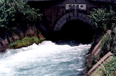
In 1837 (the17th year of reign of Emperor Daoguang), Cao Jin, the magistrate of Fengshan County faced a severe local water shortage and frequent bad harvests. In order to relieve the drought, he started to plan farmland irrigation construction, building 44 canal channels (lateral canals), excavated Jiuqu Pond, built embankments on the bed of Danshui Stream (Gaoping River) around the Jiuqu Pond section, set up a water intake to divert water into the canal, and gates on the canal depending on the terrain to adjust water volume. After two years of hard work, the canal channels in Kaohsiung City were completed. "Caogong Canal" runs through today’s Xinxing District, Qianjin District, Lingya District, Qianzhen District and Xiaogang District.
"Caogong Canal" is estimated to irrigate about 2,500 hectares of double-phase paddy fields (in the Daliao, Jiuqu, Fengshan and Xiaogang areas). In 1841, there was a severe drought, and water sources were insufficient in some areas, so another canal was built and completed in 1843, with 46 canal channels (lateral canals) also built, irrigating about 1,972 hectares of farmland.
"Caogong Canal" is estimated to irrigate about 2,500 hectares of double-phase paddy fields (in the Daliao, Jiuqu, Fengshan and Xiaogang areas). In 1841, there was a severe drought, and water sources were insufficient in some areas, so another canal was built and completed in 1843, with 46 canal channels (lateral canals) also built, irrigating about 1,972 hectares of farmland.
(II) Japanese rule in Taiwan
Japan occupied Taiwan in 1896 and in order to strengthen its rule, established the "Taiwan Temporary Land Survey Bureau" to survey and map the island at a scale of 1/20,000. In terms of farmland irrigation, the map was used as a basis to examine ponds and canals thereby gaining a comprehensive understanding of their operation, as well as the land use of private ponds and canals.
(1) Public ponds and canals period (1896-1908)
From 1902 to 1906, the construction focused on renovating old canals to reduce water loss, also known as the "old canals renovation era." At the time, there were 181 registered public ponds and canals (25 in Taipei, 67 in Hsinchu, 35 in Taichung, 20 in Tainan, 31 in Kaohsiung, 2 in Taitung and 1 in Hualien).
(2) State-owned ponds and canals (1909-1921)
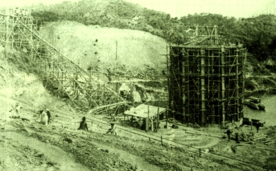
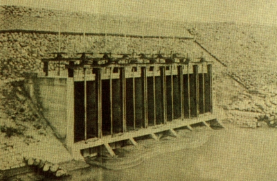
n the early 20th century, the Japanese government focused on "agricultural Taiwan," invested extensively in irrigation constructions and promoted a "10-year continuous business plan." A total of 18 reservoirs and adjustment pools were built, the largest two being Sun Moon Lake and Wushantou, both of which are off-stream reservoirs that divert water across the region, which indicates that planning and engineering were quite advanced at the time. The construction of such irrigation canals as Liugong Canal, Taoyuan Canal, Babao Canal, Lionhead Canal, Houli Canal, Caogong Canal, Jiye Canal and Chianan Canal all took place in this period. Of these, Taoyuan Canal has a total length of 1,972 kilometers and irrigates an area of 22,308.2 hectares. It is drawn from Dakekan River. The main canal starts from the canal exit of Danan Village and ends at Puting Village, Xinwu Township, with a total length of 25,309 meters. The lateral and sub-lateral canals divert water from the main canal to storage pools in the area to meet the needs of irrigation. There are 14 lateral canals and 6 sub-lateral canals, with a total length of 140,734 meters; there are 241 water inlet channels for the storage pools, with a total length of 145,971 meters; the small ditches are waterways through which irrigation water is released from the storage pools into the farmland with a total length of 686,222 meters.
However, from 1911-1913 Taiwan was hit by typhoons and the damage was severe. Many facilities were affected, and there were multiple rebuilding constructions. Therefore, this period is sometimes referred to as the "Disaster Recovery Period." "Beinan Canal", "Jizi Canal", "Yilan No. 1 Public Canal", "Yongfeng Canal", "Houlong Canal" and "Erxing River Canal" were key irrigation constructions at that time.
However, from 1911-1913 Taiwan was hit by typhoons and the damage was severe. Many facilities were affected, and there were multiple rebuilding constructions. Therefore, this period is sometimes referred to as the "Disaster Recovery Period." "Beinan Canal", "Jizi Canal", "Yilan No. 1 Public Canal", "Yongfeng Canal", "Houlong Canal" and "Erxing River Canal" were key irrigation constructions at that time.
(3) Irrigation Cooperative period (1922-1945)
The period from 1922-1937 can be called the Irrigation Cooperative period, and represents the peak of irrigation work in Taiwan under Japanese rule, during which major irrigation constructions were completed. For example, Taoyuan Canal was completed in 1924 and irrigated 22,308.2 hectares in the Taoyuan area. Chianan Canal was completed in 1930 and irrigated the Chianan Plain implementing a three-year rotation with an area of 133,741.3 hectares. The large-scale pumping irrigation construction of Jiuqu Pond was completed in 1928. Taiwan Sugar Corporation constructed underground water diversion irrigation constructions at Wannong Farm and Daxiangying Farm, and the Chianshan Pond Reservoir of Xinying Sugar Factory and the Luliao River Reservoir of Nanjing Sugar Factory were also completed and started construction respectively during this period. In 1937, the area covered by paddy fields reached its highest at 528,060.3 hectares, and the yield of brown rice reached a record 1.77 million metric tons. However, in 1937 Japan invaded China, and Taiwan was impacted. In 1941, the Pacific War started and in 1941-1943 there were also multiple major storms and typhoons, and many facilities were destroyed. In 1945, Taiwan underwent Retrocession and was taken over by the Republic of China government. In the preceding 8 years Taiwan had been devastated by wars and natural disasters and the impact on irrigation was particularly bad. The area of paddy fields fell to 486,332 hectares in 1945, the production of brown rice declined to 1.35 million metric tons in 1944 and 747,000 metric tons in 1945.
In 1930, large-scale irrigation constructions were completed in Taiwan. The focus on farmland irrigation at that time included the reclamation of coastal areas, land improvement, and the implementation of several smaller and faster so-called "irrigation works to promote increased rice production." Taiwan Development Co., Ltd. carried out land reclamations in coastal areas, its first construction being the new port of Beigang, Tainan. It built a 4,400 meters long seawall, 9,500 meters of waterways and also introduced a windbreak forest to prevent wind and sand. The irrigation water was diverted from the end of Chianan Canal.
Based on a basic survey completed in 1934, the land improvement plan was scheduled to improve 66 districts and impacted an area of 506,100 hectares. The estimated cost of irrigation and drainage construction was 124.200 million yuan, soil improvement 116.8 million yuan and outer river construction 106.38 million yuan, the total cost coming to 347.39 million yuan. A total of 39 districts were listed as part of the "11-Year Land Improvement Plan," construction started in 11 districts, was completed in 3 districts and suspended in 8 districts.
During this period, irrigation work to increase rice production was limited to those that could be completed within one year, and irrigation groups were responsible for implementing work with subsidies from the government. These covered 70% of the cost of the irrigation work in Eastern Taiwan and 50% of in western Taiwan. The construction started in 1940 and was terminated at the end of the war, with a total of 157 districts. Toward the end of the war, equipment and labor were severely limited, so work scheduled for one year often took more than two years, and small waterways were not fully completed. As such, although it was claimed to benefit 41,604.7 hectares, the outcomes did not meet expectations and the total cost was 17.56 million yuan.
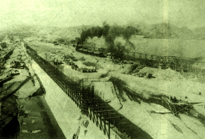
During this period, Taiwan's farmland irrigation management became centralized. With the support of a strong government irrigation organization, the adoption of technical methods and the application of reinforced concrete technology in construction, irrigation facility building developed rapidly. Important irrigation and drainage constructions completed in this period include "Chianan Canal", "Yilan Drainage Improvement," "Dananzhuang Water Supply Facilities," "Jiye Reclamation Water Supply Facilities," "Liuzi Canal and other improvement works," "Douliu Barrier Dam Renovation," "Daojiang Canal Improvement," "Haoshou Canal Improvement," "Wandan Pump," "Jintongchun Canal Renovation" and "Sanxing Irrigation Improvement." Projects under construction include “Lunbei reclamation,” “Kaohsiung Land Improvement,” "Fenglin Land Improvement," "Babao Canal Land Improvement," "Douliu Land Improvement," "Guanmiao Land Improvement," "Zhunan Land Improvement," "Upland Expansion Improvement Plan" and other work plans. The "Chianan Canal" was built in 1920 and took 10 years to complete. The main elements include:
- Water source facilities: Wushantou Reservoir, Linnei first and second water inlets, Zhongguozi water intake.
- Water supply facilities: 100 kilometers of main canals, 1,200 kilometers of lateral and sub-lateral canals, and 7,400 kilometers of small water ditches.
- Drainage facilities: the total length is 960 kilometers, and the small drainage lines extend for 6,000 kilometers.
- Tidal breakwater facilities: 228 kilometers of breakwaters and 104 kilometers of tidal breakwaters.
(III) After Taiwan Restoration
As a result of WWII, farmland irrigation facilities in Taiwan were damaged to differing degrees and agricultural development declined. After Restoration and the takeover of Taiwan by the Republic of China government, it was necessary to restore production as soon as possible, increase grain production and stabilize people's ability to make a living. Therefore, initial irrigation constructions focused mainly on restoration and were fully subsidized by the government. First, damaged irrigation facilities were repaired and work unfinished prior to Retrocession completed. After the central government moved to Taiwan in 1949, assuring access to food for the people and the army was its top priority so as to consolidate its position and better defend Taiwan. Nonetheless, there were severe droughts and water shortages from 1951-1961, with 87 floods in 1959 and 81 in 1960. Thereafter, the government determined to make a greater effort to strengthen irrigation construction, with measures including the comprehensive and immediate repair of the disaster impacted areas, and took the opportunity to improve and vigorously expand the scope of irrigation areas, while reclaiming paddy and upland fields.
Shimen and Zengwen multiple target reservoirs and Baihe and Mingde Dapu single-target reservoirs were built, with the rotation irrigation and upland irrigation construction of Ruisui and Beinanshang Canals in eastern Taiwan. In 1960, the government started to implement farmland re-adjustment to improve the agricultural production environment, expand land use, increase the size of farms, and facilitate mechanized operations for better operational efficiency. This involved re-exchanging and merging over-divided arable and simultaneously building agricultural roads and improving field drainage systems. As of 2002, 388,774 hectares of arable land had been improved, with farmland re-adjustment making an important contribution to improving the performance of farmland irrigation.
Recently, due to social and institutional changes, the development of industry and commerce and the low price of crops, the gap between agricultural income and non-agricultural income, agriculture has declined. Not only was there no development of new irrigated areas, crop cultivation area also fell.
Although the economic role of agriculture is not as prominent as it was, it remains irreplaceable when it comes to providing open living space and greenery, promoting ecological balance and ensuring food security.
In recent years, the government has continued to promote the renewal and improvement of farmland irrigation facilities, afforestation of areas around ponds and canals, and the development of water saving upland irrigation to ensure farmland irrigation facilities function well, as it moves toward the goal of modern management and the three vital functions of irrigation.